Plan Framework
Amenities & Public Space
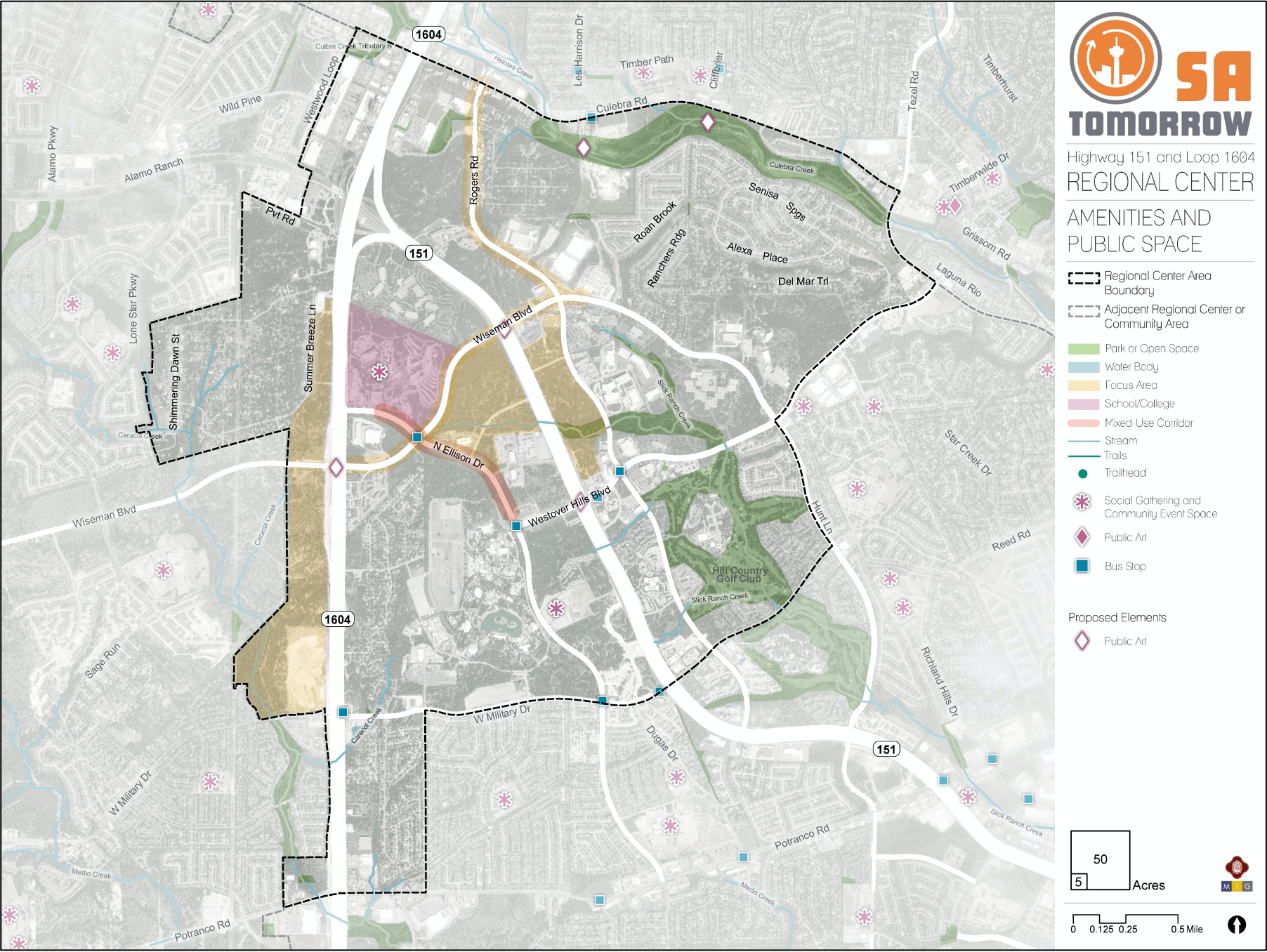
The map below highlights the Amenities & Infrastructure Framework recommendations identified for the Highway 151 and Loop 1604 Area Regional Center. Scroll down learn more about the vision for Amenities & Infrastructure in the Plan Area.
To provide specific feedback on the map, please click and drag a box on that location of the map and fill out the comment box. We would love to hear more from you!
You can also visit the bottom of this page to leave additional feedback.

Introduction
Incorporating amenities and public space throughout the Highway 151 and Loop 1604 Area Regional Center is a key factor in creating a destination and sense of community. New commercial business and campus style developments will appreciate amenities such as nearby restaurants and plazas for their employees to take lunch breaks or enjoy the outdoors. Residents in both existing and new residential developments will also look for open spaces for their children to play, high quality sidewalks to walk with their dogs, and other public spaces like community centers to gather with their neighbors. Amenities and public space improvements can establish a character for the Regional Center through elements such as public art, signage or wayfinding to direct visitors to notable destinations, and plazas for people to gather with their neighbors, fellow students, or coworkers. Features such as streetscape improvements, enhanced lighting, priority connections, and trails can increase safety for residents, employees, students, and visitors who might walk or bike in the area. Collectively, amenities and public space improvements are the missing link that make the Regional Center a unique place and destination.
While highway access to the Regional Center has contributed to it being one of the fastest growing areas in the City, rapid development and the dependency on highways and a few smaller streets to move about has led to a disconnect in overall character and accessibility. The mobility recommendations within this plan attempt to knit together the area overall, but additional considerations around amenities and public space can further connect the area and make it easier for those who live, work, or play here to get around safely and connect with their community. To further create a sense of identity, incorporating public art into the planned trail system and along the Highway 151 and Loop 1604 area roadways can establish more sense of community among residents, employees, students, and visitors.
Amenities and Public Space Components
Parks, Trails and Open Space
The Highway 151 and Loop 1604 Area Regional Center has a limited amount of publicly accessible green space within its boundary. This deficiency was one of the most commonly mentioned comments among community members and the Planning Team throughout this planning process. The lack of publicly-owned land in the area makes it difficult to designate specific park locations at this time. However, there are a number of floodplain and drainage areas that provide ample opportunities to create a linear park and trail network between campus developments and existing urban trails, and that could expand beyond the Regional Center on Culebra Creek and connect to the overall Howard W. Peak Greenway System.
Streetscape Improvements
The Regional Center includes many major corridors that must accommodate motor vehicles, pedestrian, bicycle, and public transit usage. The mobility section of this plan identifies street types based on the intersection of roadway function and adjacent land use and recommends further studies and investments according to the priorities identified for various area streets. Additionally, in order to make pedestrian and bicyclist activity safer throughout the area, it is crucial to enhance many streetscapes by widening sidewalks, adding more defined crosswalks, increasing/adding street lighting, and incorporating more landscaping and street trees. The community wants to be able to safely access nearby uses, including greenways and residences, and these features are crucial to creating this type of environment.
Character Defining Features
The Highway 151 and Loop 1604 Area Regional Center has several existing character defining features that contribute to a “natural” feel in the area. Specifically, the Highway 151 Gateway Corridor zoning overlay requires certain aesthetic regulations, such as a minimum setback, limitations on sign height and size, and requirements for greenery or screening of parking lots. These design considerations allow for the wealth of economic activity that takes place in the area to occur largely behind trees and other natural landscaping. Maintaining this natural feel is a strong desire of the Planning Team and community members, but they would also like to see more park space and other amenities created in the area. Highlighting the prominent corridors, regional access, and creating opportunities for internal trails will provide much needed space for recreation that is missing in the Regional Center.
Recommendation #1
Create more public green space wherever feasible, including the continuation of the Howard W. Peak Trail System through Culebra Creek.Throughout the meetings with Planning Team and community members, the lack of area park space was one of the most consistent topics brought up by residents. Given the lack of accessible park and open space in the Regional Center, this plan recommends that future areas be identified, perhaps those within utility easements or floodplain areas, as potential greenways and publicly accessible open spaces. The Howard W. Peak Trail System has a planned expansion from Cathedral Rock Park to Culebra Creek Park to complete the Leon Creek Trail system, which should be encouraged for the area.
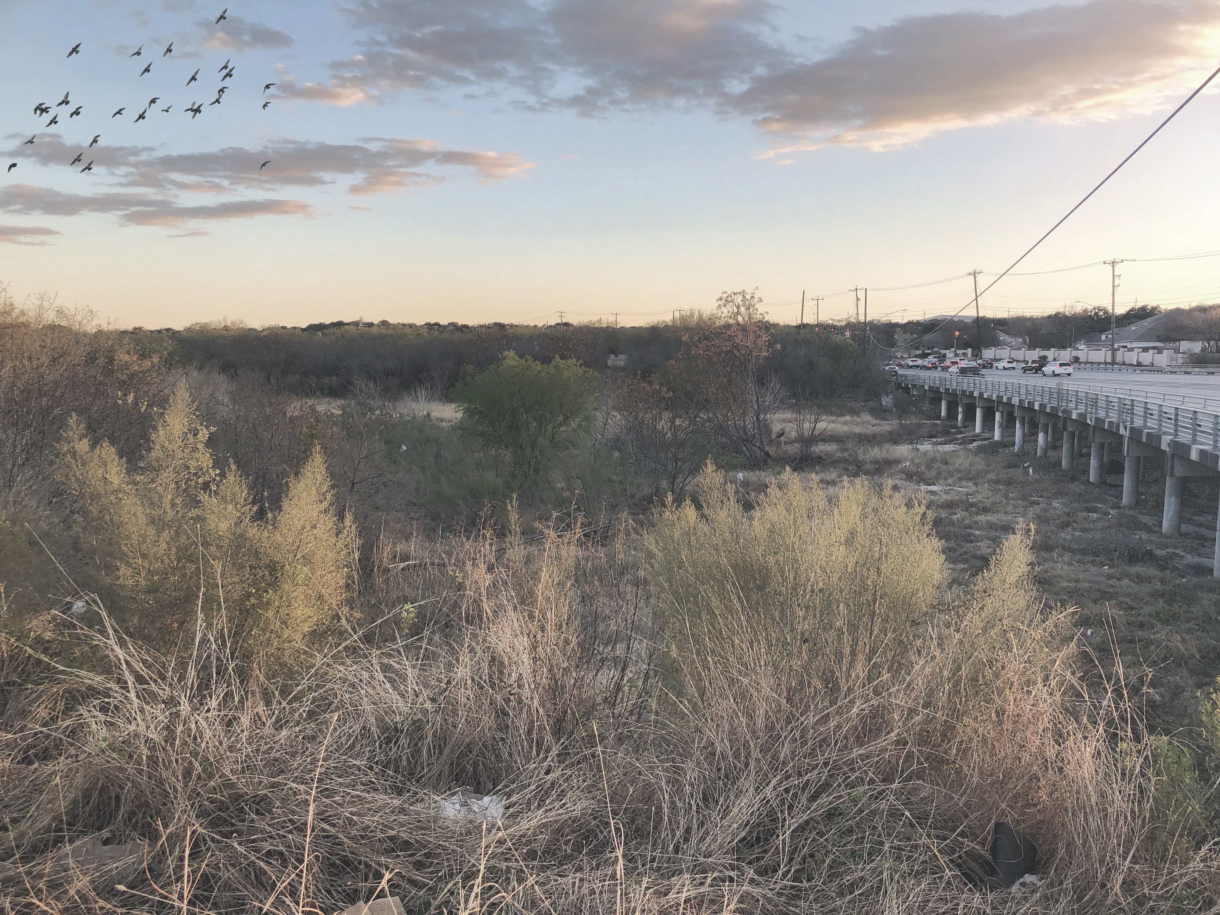
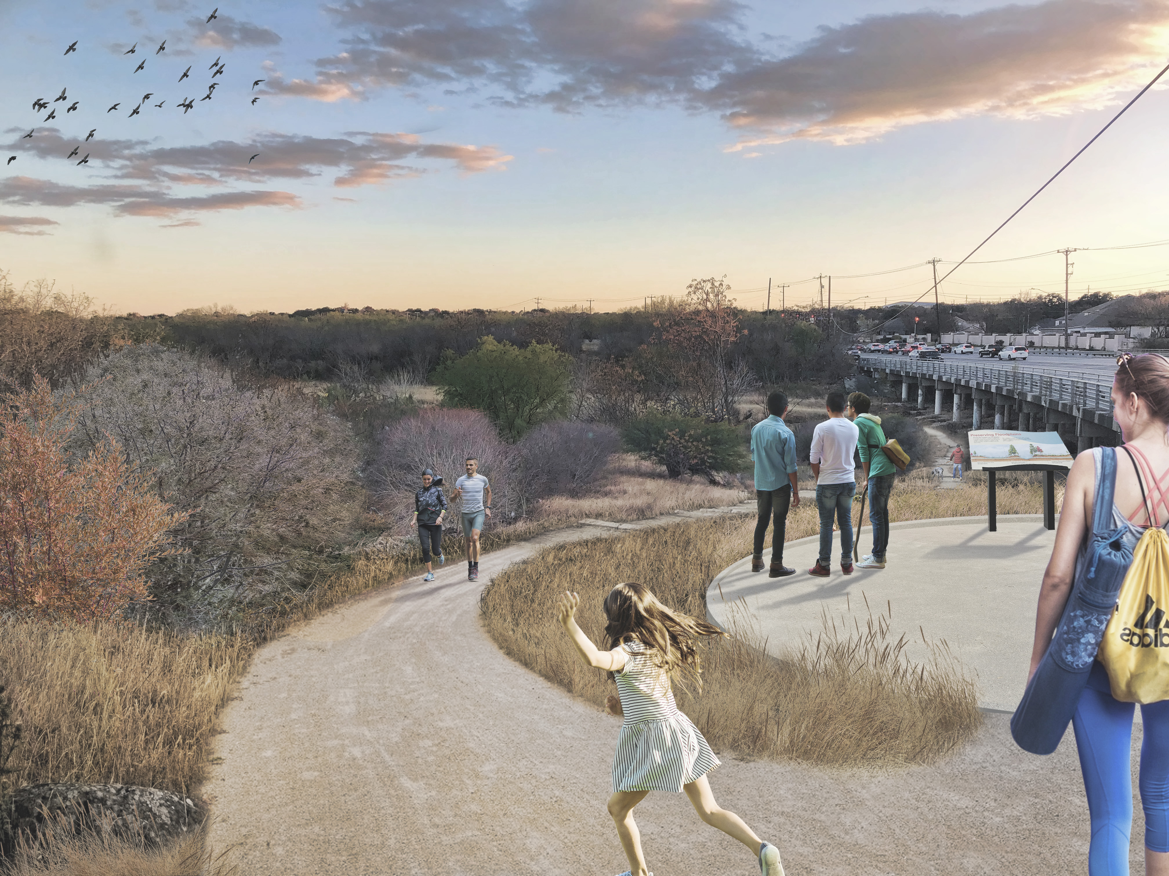
Figure 1: Conceptual Rendering of the expansion of the Leon Creek Greenway through Culebra Creek, looking south along Culebra Road
Recommendation #2
Establish character defining elements unique to the Regional Center.Proposed amenities and public space improvements are key for creating a defining character for the Highway 151 and Loop 1604 Area Regional Center. Public art, such as statues, monuments, sidewalk art, murals, and crosswalk design, along the Highway 151 and Loop 1604 roadways and the proposed internal trail network will help establish these areas as recognizable corridors in the Regional Center. Incorporating public art and wayfinding of varying scales that has a cohesive theme will help unify neighborhood, commercial, and natural areas that are currently disconnected in character and design.
Public art is an element that creates cohesion throughout the Regional Center, but it also provides a sense of belonging for residents and boosts community pride. Well designed public art and wayfinding can also serve as an economic development driver. It creates destinations within the Regional Center, potentially bringing in visitors from throughout the City. The theme of these character defining elements could highlight the origins or existing attributes of the Regional Center, such as the natural landscape and tree canopy in the area.
Recommendation #3
Create more areas and opportunities for community gatheringResidents and workers in the area stressed a desire to have more places to gather, such as a public community center or perhaps a private mixed-use development with shops, restaurants, and a plaza space for gathering. As the area grows, there will be an increased need for more gathering places and community amenities. While many of the single-family neighborhoods already have areas such as parks or clubhouses, these kinds of spaces are not available to others within the area. Several areas are identified for Regional Mixed-Use within the future land use map - these areas would be ideal locations for gathering spaces or other community amenities.