Plan Framework
Mobility
The map below highlights the Mobility Framework identified for the Highway 151 and Loop 1604 Area Regional Center. Scroll down to learn more about the vision for Mobility in the Plan Area.
To provide specific feedback on the map, please click and drag a box on that location of the map and fill out the comment box. We would love to hear more from you!
You can also visit the bottom of the page to leave additional feedback.
.png)
.png)
Background and Vision
In 2016 the City of San Antonio adopted the SA Tomorrow Multimodal Transportation Plan, to make our city’s transportation system “sustainable, safe, convenient, efficient, and inclusive of all modes.” The plan adopted by City Council established “a shift in focus from moving vehicles to moving people,” in order to manage traffic congestion and improve transportation choices. The plan identified two primary and interdependent methods for managing future traffic congestion:
- Develop land use patterns and policies to promote local trips
- Encourage more, beyond personal vehicles, to connect Regional Centers
A city’s land use pattern is inextricably linked to its mobility options and traffic concerns. The SA Tomorrow Multimodal Transportation Planacknowledged that San Antonio cannot build its way out of congestion by continuously adding additional lanes to major highways. Rather, it must take a holistic approach to improve mobility by implementing the Comprehensive Plan through future land use planning. By welcoming more people to live, work and play in urban and regional centers, and along transit corridors, the city can offer shortened trip lengths, more transportation choices, and an improved quality of life.
The combined cost of housing and transportation (commonly referred to as H+T) is often a large portion of a household budget. In terms of affordability, experts recommend that a household spend no more than 45% of their income on H+T. However, the average household in the Greater San Antonio Region spends more than this recommended share, with 53% of an average household income going toward housing and transportation costs. Walkable communities that provide great transit options can reduce transportation costs for the average household. If people have an alternative to driving alone, transportation costs are generally stable even when gas prices rise. As more people choose to reach their destination on foot, bicycle, or transit, the number of cars on the road will be reduced. This will in turn, minimize traffic delays for those who choose to drive.
Experiencing continual growth for the last several decades, the Highway 151 and Loop 1604 Area Regional Center has quickly transformed from ranchland and very few residential developments into a center for recreation, economic activity, and many housing developments. Major road infrastructure, such as State Highway 151 and connections to US 90 and Loop 1604, supported major growth in tourism in the 1990s, with the arrival of SeaWorld San Antonio and the Hyatt Regency Hill Country Resort. Today, the Regional Center has emerged as a major employment node with a diverse employment base anchored by Wells Fargo, Capital Group, Frost Bank, and other large data companies including GM Financial, Microsoft, and QVC. In addition to ample employment opportunities, this area is home to the Northwest Vista College, which provides higher education for thousands of students each year.
The Highway 151 and Loop 1604 Area Regional Center is bisected by Highway Loop 151 and bordered on the west by Loop 1604. These major highways provide access to the area’s employment opportunities, but also serve as barriers to those traveling between destinations within the Regional Center. Highway interchanges and traditional suburban land use patterns cause traffic congestion issues throughout the community. The vision for this Regional Center is to provide safe and efficient transportation among all modes of travel by creating more transit supportive land uses and encouraging transportation options that will alleviate future pressures on transportation corridors, while supporting growth.
Highway 151 and Loop 1604 Area Regional Center’s Mobility Needs
Transportation investments must be continuously made to move large volumes of freight efficiently, to link neighborhood developments to growing employment opportunities, and to provide adequate transit routes that connect to regions outside of the plan area. Growing populations demand streets that not only carry people, goods and services, but that also serve as playgrounds, parks, and public spaces. The key mobility needs identified in this Regional Center include:
- Balancing mobility between many mixed-use corridors and high functioning arterials while maintaining “natural” character;
- Improving neighborhood connectivity and infrastructure quality;
- Supporting high capacity transit as a catalyst for economic development; and
- Connecting neighborhoods to trail infrastructure and parks by taking advantage of existing rights-of-way and identifying opportunities for pedestrian and bicycle infrastructure.
A set of high-level street classification recommendations were developed to guide decision-making and address the transportation needs in the Highway 151 and Loop 1604 Area Regional Center. Recommendations shown in the Mobility Framework Map include street priorities for travel modes (i.e., automobiles, freight, transit/pedestrians), intersections identified for enhancements, and mobility hubs proposed for transit service. Street type and use recommendations are shown in the Street Types map. The mobility recommendations listed below will be further refined in a coordinated manner with the City’s Public Works Department and other relevant partners such as the Texas Department of Transportation (TxDOT), VIA Metropolitan Transit, and the Alamo Area Metropolitan Planning Organization (AAMPO).
Highway 151 and Loop 1604 Area Regional Center Mobility Framework
The Mobility Framework lays out the vision for accommodating the expanding mobility needs of the Highway 151 and Loop 1604 Area Regional Center. Principle considerations to ensure a mobility network that is safe and inviting for people who walk, shop, park, and drive in the Regional Center, include Modal Priority Corridors, Pedestrian Focus Areas, Intersection/Crossing Enhancements, and Mobility Hubs.
Modal Priority Corridors
Streets play a multifaceted role in the plan area, serving as arteries for traffic and as public spaces for walking or cycling. Changes to street design can support the future land use plan and the vision for the Regional Center. The modal priority corridors are differentiated in varying colors in the Mobility Framework Map. Modal priority reflects the degree to which motorists, bicyclists, transit users, and pedestrians will interact with and utilize the corridor. Modal priority corridors guide design treatments to benefit a particular mode, but do not exclude other users. Establishing priority for pedestrians or transit over cars or bikes, for example, can help guide tradeoff decisions during the design of a specific street.
Automobile
Automobile corridors are envisioned to support high levels of daily motor vehicle travel. These corridors - interstates, highways, arterials, and primary roadways - provide connections to major destinations and link the Regional Center to other plan areas. Significant automobile corridors in the Highway 151 and Loop 1604 Area Regional Center include Culebra Road, Westover Hills Boulevard, and W Military Drive, all of which traverse east-to-west and have been identified to enhance mobility within the regional center and to other parts of the city. Automobile corridor improvements can relieve traffic congestion and enhance roadway design, to increase the safety of motor vehicle travel.
Freight
Freight corridors are envisioned to support the movement of high levels of goods by freight trucks that travel between industrial or commercial areas and major destinations. Priority freight corridors in the plan area include Loop 1604, Highway 151, and Potranco Road.
Bicycles
Bicycle corridors are envisioned to support biking as a convenient, safe, and comfortable option for all ages and abilities. An integrated network of bicycle routes and well-designed streets in key activity areas can fill the gaps in the multimodal system this plan hopes to support. The mobility framework focuses on completing the bicycle network and recommends new connections to directly access trails and other amenities. The two priority bicycle corridors in the Highway 151 and Loop 1604 Area Regional Center are along 1) Copperfield Road –to provide safe bicycle connections from residential areas to locations such as the San Antonio Blue Ramp Skatepark, SeaWorld, the Trophy Ridge Recreation Center, and Nautilus Amphitheater, and 2) Impala Summit—to provide access to the Westover Hills and Stonegate neighborhoods, with the possibility for future access to the extension of the Leon Creek Greenway through Culebra Creek behind these neighborhoods.
Multi-Use Trail
Multi-use trail corridors are envisioned as continuous, separated arteries that provide combined pedestrian/bicycle paths that connect numerous destinations, such as parks, shops, schools, libraries, and residential areas. A multi-use trail provides access points to regional amenities and improves connections for people who walk, stroll or bicycle. Within this Regional Center, there is potential to develop multi-use trail pathways that provide east-west connections along Culebra Creek, W Military Drive, Westover Hills Boulevard, and Wiseman Boulevard. There is an additional opportunity to provide a north-south connection between Easterling and Impala Summit, which would connect to Culebra Creek through the Westover Valley neighborhood.
Balanced/Multimodal
Balanced and multimodal corridors are envisioned as “complete streets,” a type of street design that considers all users and accommodates persons of all ages and abilities, whether children, older adults, or persons with disabilities. These corridors balance the priorities of multiple modes and require continual community conversations and case-by-case design to best align with the community vision. The function of the road, level of traffic by mode, and adjacent land use and intensity will help determine the road type and design features. As the Highway 151 and Loop 1604 Area Regional Center continues to grow in terms of employees, residents and commercial services, mobility needs can be addressed by developing multimodal and balanced transportation access throughout the entire plan area. Ellison Drive and Rodgers Road have been identified as two priority corridors that bisect the Regional Center and provide an opportunity to enhance mobility options for motorists, bicyclists, and pedestrians.
Pedestrian Focus Areas
Pedestrian focus areas refer to specific nodes of pedestrian activity that provide adequate and safe pedestrian infrastructure connecting residential areas to amenities such as transit routes, commercial developments, parks, schools, and restaurants. These areas should have large sidewalks, safe intersections, ample crossing opportunities, and other design characteristics focused on keeping pedestrians safe. Community members identified pedestrian priority locations near 1) major destinations, including the intersection of Military Drive and Ellison Drive, 2) areas with ample amenities and destinations, including the One Frost/Kohls business park, and 3) major neighborhood origins, such as along Culebra Road.
Intersection / Crossing Enhancements
Intersection and crossing enhancements are envisioned as intuitive and predictable crossings for all users. Enhancement locations are identified where crossing is considered a priority, where complex movements occur, and when potential conflicts are likely between pedestrians, motorists, and bicyclists, all who share space. Whether signalized or un-signalized, crossings where a high level of multimodal activity is considered and planned for, will facilitate predictability for all users. Intersection enhancements can include the lowering of vehicular travel speeds and ensuring high pedestrian visibility. The priority intersection and crossing enhancement locations are denoted on the Mobility Framework Map with orange squares.
Mobility Hubs
Mobility hubs are envisioned as scalable nodes that host mobility options, such as frequent transit, shared rides, bicycling, and micro-mobility. These areas link multimodal access and connectivity with amenities such as adequate lighting, shelters, benches, real-time information, accessible sidewalks, and pedestrian crossings. A large-scale mobility hub is identified at the intersection of Ellison Drive and Wiseman Boulevard to serve Northwest Vista College, and three smaller hubs are identified along W Military Drive, Westover Hills Boulevard, and at Loop 1604 and Culebra Road.
Highway 151 and Loop 1604 Area Regional Center Street Types
As communities evolve and grow, so do the demands on the mobility system. The location and type of growth in an area or along a corridor help determine the demand on the transportation network and the viability of various transportation options. This interdependence makes it crucial to plan for transportation and land use collectively. Streets are organized not only by role and function but also by their character and surrounding context.
Land uses which encourage a mix of uses and higher density developments located on major roadways will lead to additional pedestrians, bicyclists, transit riders, cars, and freight delivery trucks of various sizes. A future land use plan also influences other factors, such as drop-off delivery zones, shared mobility hubs, and walkability. The map below identifies the interactions between future land use and transportation plans. The street type classifications integrate transportation and land use, to guide context-sensitive mobility solutions.
Creating Street Types
To conceptualize the types of streets needed to align with future land use designations, several Street Types were developed. Streets are categorized by “functional classification” by the City of San Antonio’s Major Thoroughfare Plan. This functional classification describes the intensity of vehicular traffic on the roadways. For example, a classification of Super Arterial has the primary job of moving cars quickly to further destinations than a local/other classification, which would have slower vehicle speeds and lighter traffic with a more pedestrian-friendly environment.
To create the Street Types, these functional classifications are intersected with the Land Use Context. The Functional Classifications are shown in the left column of the matrix below, and the Land Use Context is shown in the top row. The cells of this table show the Street Types, which are shaded in a gradient of colors – with a lighter blue signifying a priority for moving vehicles, and a darker blue signaling a focus on people and places. As an example, a local road in a mixed-use context would be very walkable, and allow people to walk or bike between shops or residences. On the contrary, some roads are necessary for moving vehicles and freight, which could be examples of Super Arterials, Primary Arterials, or Rural roads in Suburban Commercial, Industrial, or Mixed-Use areas.
Not all streets can be fully for cars because the future for San Antonio is more walkable and includes more transportation options. Contrastingly, not all streets can be fully for pedestrians, because there is still a need to move goods, provide fast and efficient transit, and to accommodate people traveling longer distances. This Street Type exercise allows us to see which streets should be prioritized for future changes to make them consistent with the future land use map, and to serve the vision for the Regional Center and the city overall.
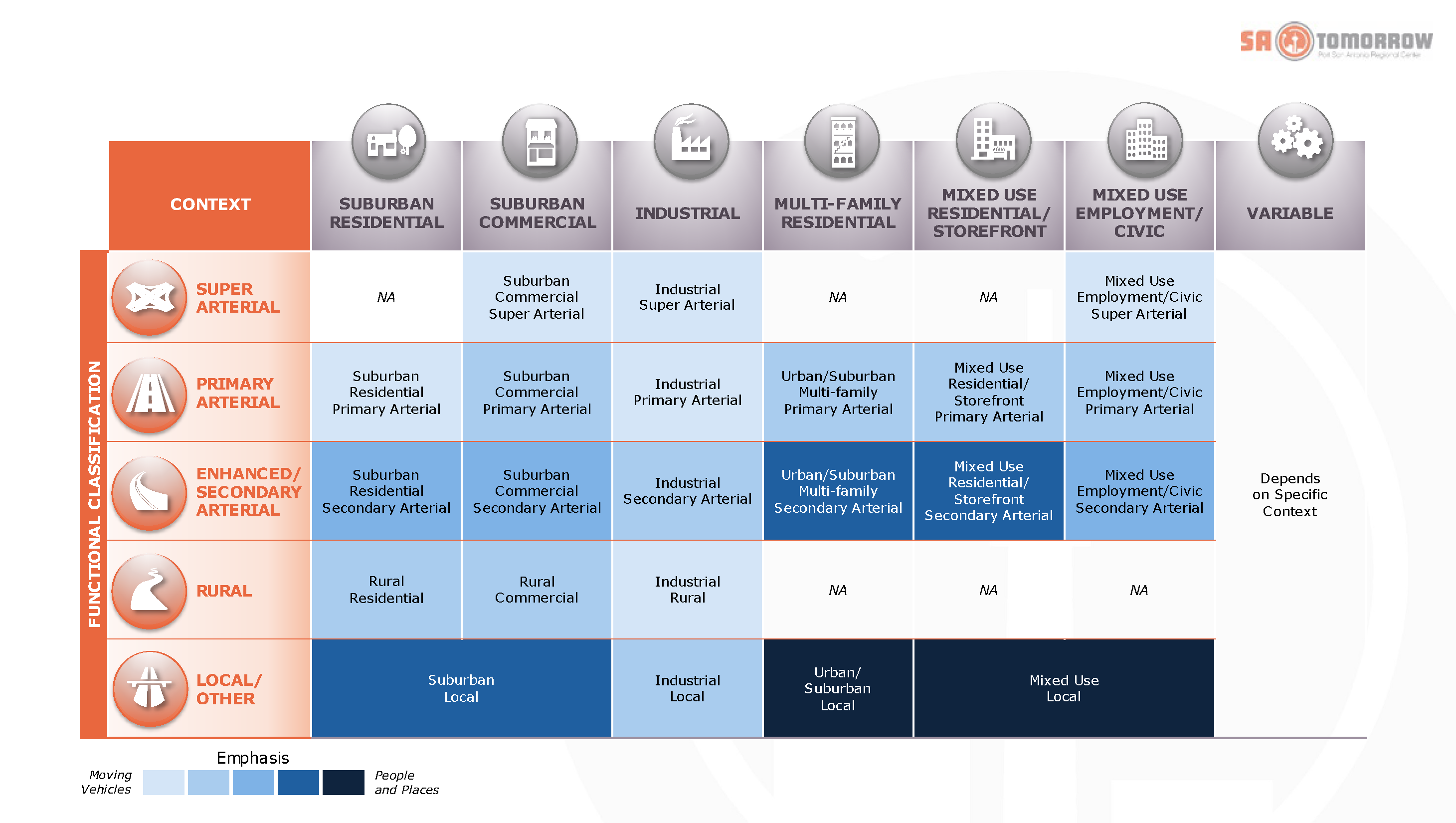
Street Types: Functional Classification and Land Use Context Matrix
Street Types in the Highway 151 and Loop 1604 Area Regional Center
This combination of Functional Class and Land Use Context created a menu of Street Types that was then applied to the Highway 151 and Loop 1604 Area Regional Center. As shown in the Existing Street Types Map below, the intersection of the functional class and Land Use Context are shown in varying patterns and colors on each of the major roadways in the Regional Center.
The major highways of Highway 151 and Loop 1604 are classified as major freeways by the Major Thoroughfare Plan – rapidly moving goods and traffic with major commercial uses on either side of the highway, and perhaps some mixed use in the future.
Wiseman Boulevard, Rogers Road, Westover Hills Boulevard, and Culebra Road are classified as Secondary Arterials in a Mixed-Use Residential/Storefront Context. These streets still need to move goods and traffic, as they are some of the main inner roads of the Regional Center, but in the future the surrounding context of these roads is set to become more Mixed-Use with a residential and retail focus. This means the streets should accommodate more modes of travel such as pedestrians, bicyclists, and transit to attract and accommodate more residents and visitors to the mixed use destinations along these roadways.
Other parts of the Regional Center are envisioned currently, and in the future, as employment centers. The roadways supporting these uses, such as W Military Drive, N Ellison Drive, and the southern portion of Rogers Road below Westover Hills Boulevard, are classified as Secondary Arterials but in a Mixed Use-Employment Context. These roadways still need to move more goods, but can also serve the employees who work in these areas. There might be fewer surrounding residential and retail uses, but perhaps the employees who work in these areas would like sidewalks, transit, and bicycle infrastructure to better access other parts of the Regional Center.
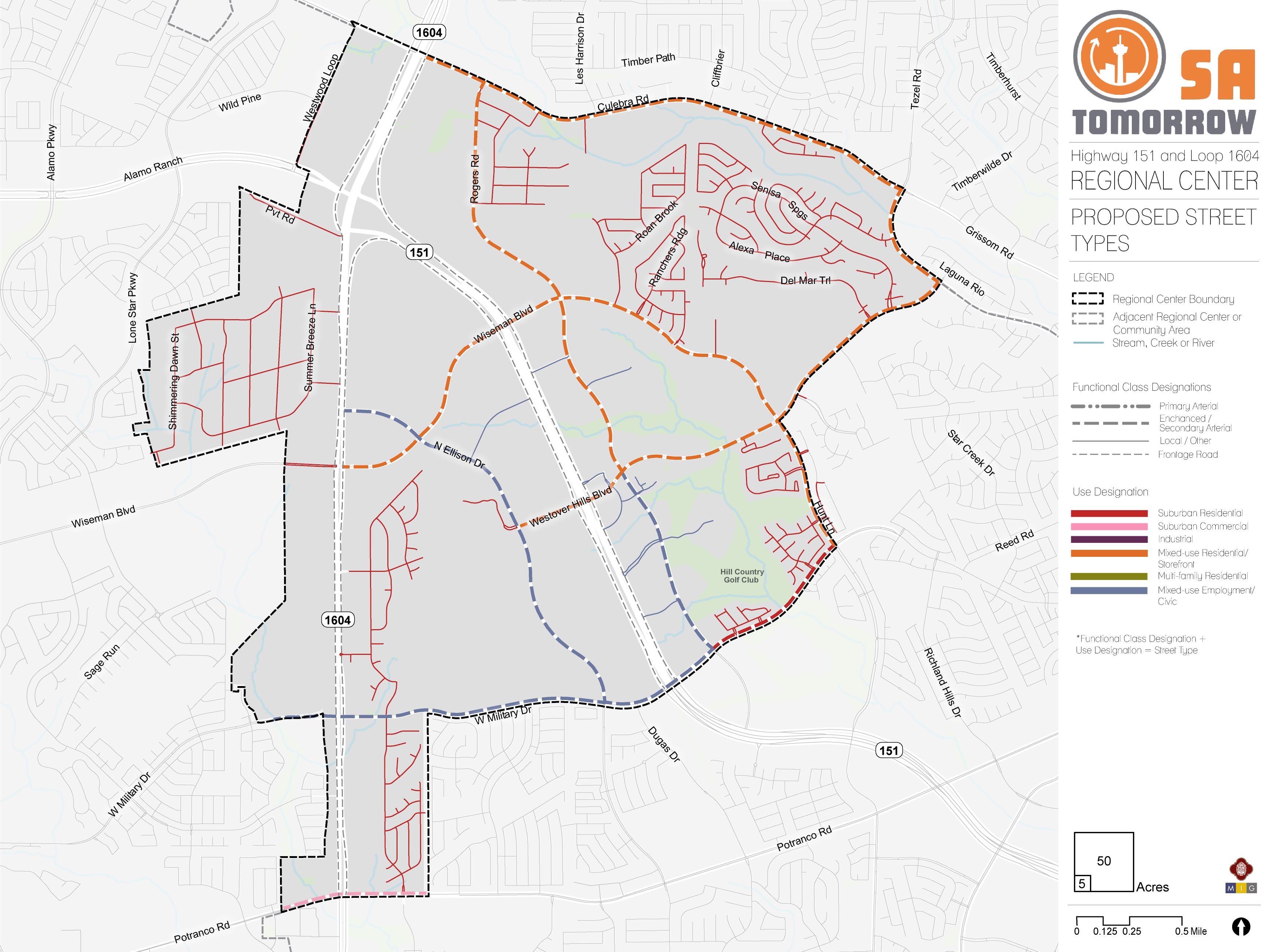
Existing Street Types Map
To more simply show the vision for the Street Types in the Regional center, Figure ## shows the streets classified into the same gradient of intensity between car-focused and people/places-focused streets. As shown on the map, most of the roadways in the Regional Center should have a more people and places-focused approach going forward to support the future land use vision. Major, auto-focused thoroughfares will still be needed, but many smaller roads in mixed-use contexts should provide more modes of travel available to residents and employees.
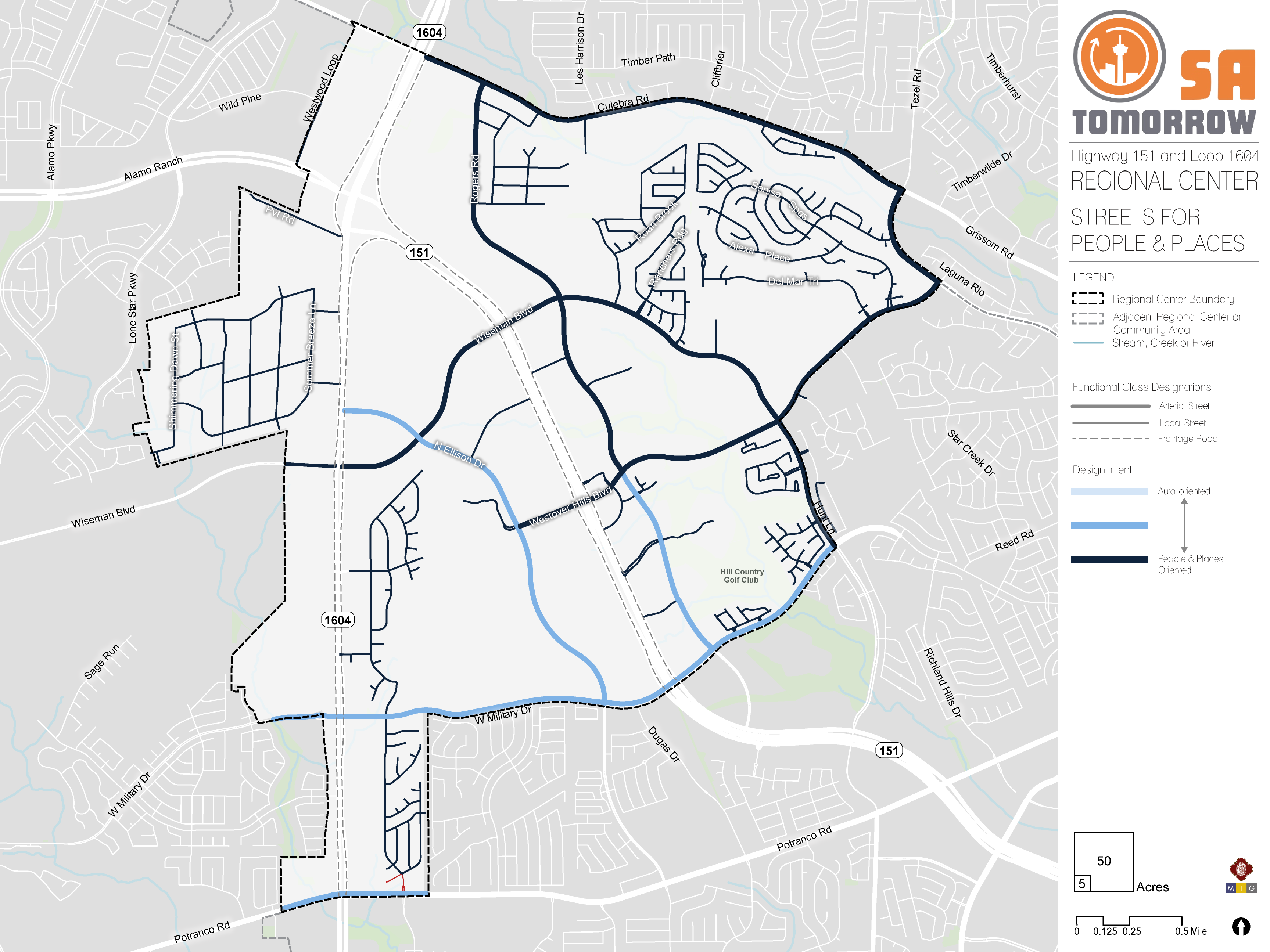
Future Street Types: Streets for People and Places
Relationship between Street and Building
Safe and vibrant streetscapes are influenced by the way in which buildings relate to and integrate with the sidewalk realm, and differing levels of this interaction will be present in the Regional Center. To create a more walkable environment, it is key to minimize building setbacks - the distance between the edge of the public right-of-way and the front of a building. Buildings that are adjacent to a sidewalk provide pedestrians direct connections to destinations and create an enlivened urban space with opportunities to activate ground-floor uses and provide shopping or entertainment offerings.
Smaller setbacks are characteristic of Mixed-use Local, or Urban/Suburban Local street typologies, which prioritize pedestrian-oriented design. Meanwhile, larger setbacks that can accommodate front-end parking are more characteristic of secondary arterials (whether suburban, industrial, mixed-use or urban). Primary arterials are designed to move vehicles and may require larger setback minimum requirements to accommodate additional parking in front of buildings, and to provide a buffer from fast-moving traffic to any pedestrian activity.
Vehicle Speeds
A successful street hierarchy aligns travel speeds with street usages and roadway function. While major regional roads may require higher speeds to accommodate heavy traffic flows, most smaller roadways serve lower volumes of vehicles. On these roads, lower speeds can ensure a safer environment for both vehicles and pedestrians/cyclists.
Street typologies that focus on moving vehicles, such as Suburban Commercial, Residential, or Industrial Super and Primary Arterials, will feature higher speeds. However, typologies that focus on people and places—such as Mixed-use, Multi-family, Urban/Suburban Local Roads and Secondary Arterials—will feature lower speed limits, to increase road safety for both people and vehicles.
Parking
Parking provides access to work, retail, or entertainment. Drivers in search of parking create serious traffic and safety challenges. Incorporating safe street design elements, such as buffering between bike and travel lanes, can create a safer on-street parking environment.
Street types that emphasize people and places, such as those in Mixed-use or Multi-family contexts, restrict the supply of parking overall, which allows for more active uses, denser environments, and connectivity for pedestrians and cyclists. Meanwhile, intermediary street typologies that support vehicles as well as people and places, will likely offer some on-street parking, in addition to smaller on-site lots. Conversely, Suburban Contexts or Super and Primary Arterials may eliminate on-street parking altogether, in favor of large surface lots and structures.
Curb Access
Space between the curb and travel lanes provides an opportunity to serve many uses such as driveway access, bus lanes, cycle tracks, on-street parking, bicycle parking, drop-off delivery zones, or shared mobility hubs. This flexible zone can be converted based on demand and play a role in street activation. The design of the curb influences how cars and people enter and exit work, residential, and retail environments. In areas where traffic and turning movements increase the risk of accidents, implementation strategies will reduce conflicts between driveway traffic and pedestrians, and improve roadway safety.
Suburban Commercial contexts and Super or Primary Arterials focus on the ease of ingress and egress for vehicles, while Mixed-use or Local street typologies focus on moving people, and emphasize how vehicle access can coexist with safe, walkable environments.
Lane Width
Lane width determines how cities can allocate space for vehicles, transit, trucks, and bikes. Streets often contain dedicated space for bike lanes, parking, safety islands, and travel lanes. The lane width will vary based on the surrounding context and modal priority; transit, freight and emergency response vehicles require wider travel lanes.
Wider lane widths are designed to move vehicles in high-speed environments. For example, a Suburban Primary Arterial will be wide enough to efficiently move passengers through residential and commercial environments, while Mixed-use Local or Suburban Local environments support narrow lanes to reduce crossing distances for pedestrians and to help promote slower, safer driving speeds.
Recommendation #1
Continue Implementing the San Antonio Vision Zero Action Plan.The City of San Antonio’s Vision Zero initiative aims to achieve zero fatalities on the community’s roadways and improve roadway safety for all users, whether driving, bicycling, or walking. The Vision Zero initiative evaluates and makes recommendations to improve safety in Severe Pedestrian Injury Areas (SPIAs) - locations where two or more crashes close together have resulted in severe pedestrian injuries. Potential tools for improving pedestrian safety in Severe Pedestrian Injury Areas include Leading Pedestrian Intervals, Medians, and Pedestrian Crossing Islands, based upon analysis of the unique factors that contribute to crashes in each location and depending upon the results of engineering assessments. Another approach to improve safety involves dedicating more space in the roadway to bicyclists and pedestrians. From new ways to protect bicycle lanes with separated barriers such as bollards, to landscaping and planters and raised medians, San Antonio has many available tools to improve pedestrian and bicycle safety. The City of San Antonio Vision Zero Action Plan lists additional tools for improving pedestrian and bicycle safety.
The Highway 151 and Loop 1604 Area Regional Center has a wealth of opportunities for improving transportation and safety, such as improving crossings and investing in complete streets. In particular, the 2018 San Antonio Severe Pedestrian Injury Areas Report (pages 31-32) identifies a Severe Pedestrian Injury Area (SPIA) within the Regional Center, on Potranco Road from Loop 1604 to Rousseau Street, that should be prioritized for study and investment.
Additional analysis of pedestrian, bicycle, and vehicle crash data, along with community input, also identified additional points of conflict between people and vehicles that should be studied for future improvements. Major highways, such as Loop 1604 and Highway 151, and their associated frontage roads, create barriers for many pedestrians and bicyclists. The unwelcoming environment of vehicular speed and limited amenities hinders travel options for those walking or bicycling. Major roadways, like Culebra Road and Potranco Road, have insufficient accommodations and less than ideal conditions for pedestrians and bicycles to either travel on or safely cross. Employing strategies to improve the experience for pedestrians can greatly increase safety in the Regional Center.
Recommendation #2
Complete the multimodal mobility network and establish new connections through partnerships.Multimodal and connected networks are key aspects to providing mobility for all users, regardless of ability or financial status. Transit improvements ensure areas are accessible, as bicycle and pedestrian infrastructure provide last-mile connections to and from transit and key destinations. Urban design improvements, such as driveway relocation, street calming, and complete streets, further support transit improvements while providing safe and inviting spaces.
Balanced/Multimodal Streets
Balanced and multimodal streets, or “complete streets” are envisioned for the Highway 151 and Loop 1604 Area Regional Center, providing safe roadway designs for vehicles, pedestrians and cyclists. The following streets are recommended for future study by the Public Works Department for complete streets improvements:
- Rogers Road from Culebra Road to W Military Drive;
- Wiseman Boulevard from west of Loop 1604 to Westover Hills Boulevard; and
- North Ellison Drive from Loop 1604 to W Military Drive.
Priority Multi-Use Trails
Key Leon Creek Greenway trail connections on the periphery of the Highway 151 and Loop 1604 Area Regional Center provide critical continuous arteries of separated pedestrian and bicycling infrastructure network, connecting numerous parks, retail locations, schools, and libraries. The critical access points to these regional amenities provide opportunities to improve connections for people who walk or bicycle, through deliberate side paths or on-road infrastructure like crosswalks, sidewalks and bicycle facilities. New connections are envisioned along:
- Wiseman Boulevard from Loop 1604 to Westover Hills Boulevard;
- Westover Hills Boulevard from North Ellison Drive to Culebra Road;
- Easterling from Culebra Road south to Culebra Creek Greenway connecting across Culebra Creek between Easterling and Impala Summit; and
- Copperfield Road from it’s northern terminus at Highland Mist Lane to either Wiseman Boulevard or North Ellison Drive.
Preferred Bicycle Routes
In many parts of the Regional Center, bicyclists currently ride in mixed traffic on high-speed and high-volume roads. Additional bike infrastructure, such as designated lanes, is highly recommended where feasible and as part of “complete streets” and other improvement projects. These measures will improve riding conditions for today’s commuters and welcome newer, less confident bicyclists that are unaccustomed to riding alongside vehicles. The provision of bicycle parking and micro-mobility options at transit stops provides an important connection for people who want to access transit by bicycle and helps to address the ‘last mile’ challenge. Overall, supporting bicycle infrastructure helps connect people to and from their destinations and transit.
Based on input from the Planning Team and other community stakeholders, the Highway 151 and Loop 1604 Regional Center Plan identifies priority bicycle routes for the Regional Center including:
- Copperfield Road from Rousseau Street north toward North Ellison Drive and Wiseman Boulevard;
- Rousseau Street from Copperfield Road to Potranco Road; and
- Impala Summit, connecting north to the proposed multi-use trail.
Specific corridor areas identified for balanced and multimodal complete streets, along the Rogers Road and North Ellison Drive roadways, would also incorporate bicycling infrastructure as a component of the design - based on future studies by the Public Works Department - to determine feasibility and the types of facilities needed.
Recommendation #3
Manage transportation demand through targeted employer-based solutions.While congestion can be viewed as a sign of economic health, congestion delays waste valuable time and create transportation emissions that reduce air quality. The transportation industry has learned that a community cannot build itself out of congestion by continuously adding additional lanes, however, a series of targeted strategies can provide more travel options and reduce the demand on its roadways. The shift of users from driving alone to alternative modes of transportation can alleviate congestion along a corridor or within the area. This becomes more viable when alternatives are convenient and integrated into the daily life of area residents and employees. To support economic and residential growth and continue the vibrancy of the region’s economic centers, the community needs easy and reliable choices for traveling to and from work, school, and other key destinations. Employer-based, public-private collaborations, such as an on-demand, shared-ride shuttles between major employment campuses, retail locations, and transit hubs ensure connectivity throughout the Regional Center. Daytime shuttles provide options for employees who leave their job site for lunch or run errands. Other employer-based policies, such as telecommuting, compressed workweeks, and flexible schedules can reduce the demand on the transportation network.
Recommendation #4
Support VIA Metropolitan Transit service by prioritizing transit supportive policies and infrastructure near transit facilities, stations, and stops.Efficient and reliable VIA Metropolitan Transit service depends on transit-supportive policies and infrastructure, such as a cohesive network of accessible sidewalks, crosswalks, and curb ramps improvements, to provide safe connections to transit facilities for pedestrians, cyclists, or those getting dropped off from a vehicle.
Providing last-mile connections between transit and key destinations, such as jobs and public spaces, improves mobility throughout the Regional Center while supporting walkability and safety for all transportation users. Key components of VIA Metropolitan Transit’s approach of making a place transit-supportive are streets designed for pedestrians, improving the safety of all users, and supporting compact, mixed-use developments that provide access to a variety of services reachable on foot.
Every person that gets on or off a bus or other transit vehicle is a pedestrian. Safe, comfortable, and direct access to transit for people who walk or bike to a transit station or stop will improve their experience as a transit rider and will increase the number of people who choose to walk, cycle, or take transit as their preferred travel choice. These improvements also contribute to the overall quality of neighborhoods and communities.
Key improvements that could improve transit mobility include bus-only lanes that give priority to buses in times of peak hour traffic; queue jump traffic signals that allow buses to advance ahead of traffic; transit priority lanes; and bus bulbs to allow buses to pick up passengers without entering/exiting a travel lane. Studies will need to be conducted to determine the appropriateness for each strategy for the areas of local congestion, including:
- Loop 1604 from Military Drive to Wiseman Road;
- Wiseman Road from Loop 1604 to North Ellison Drive; and
- North Ellison Drive from Northwest Vista College to Westover Hills Boulevard.