Plan Framework
Focus Areas
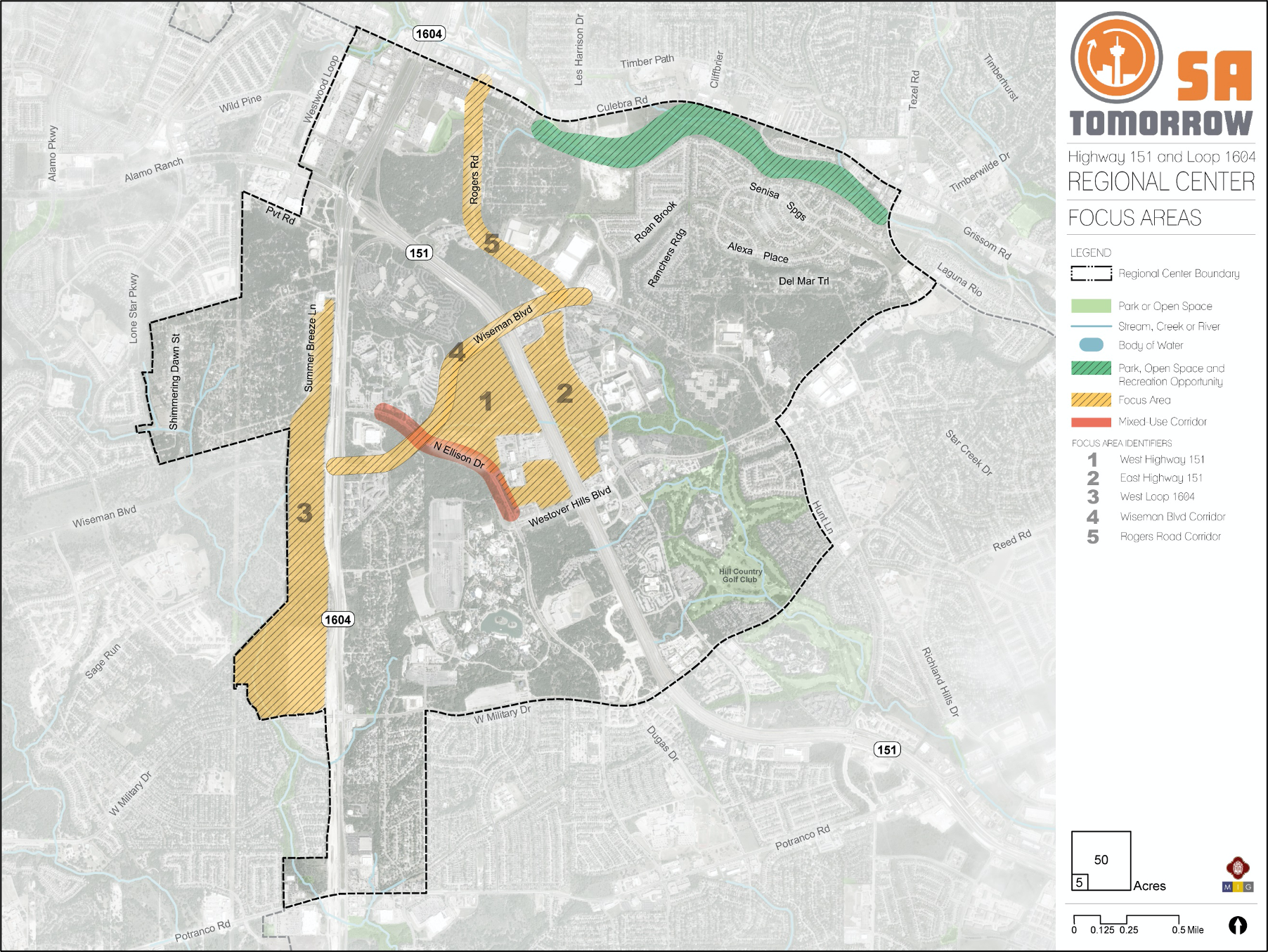
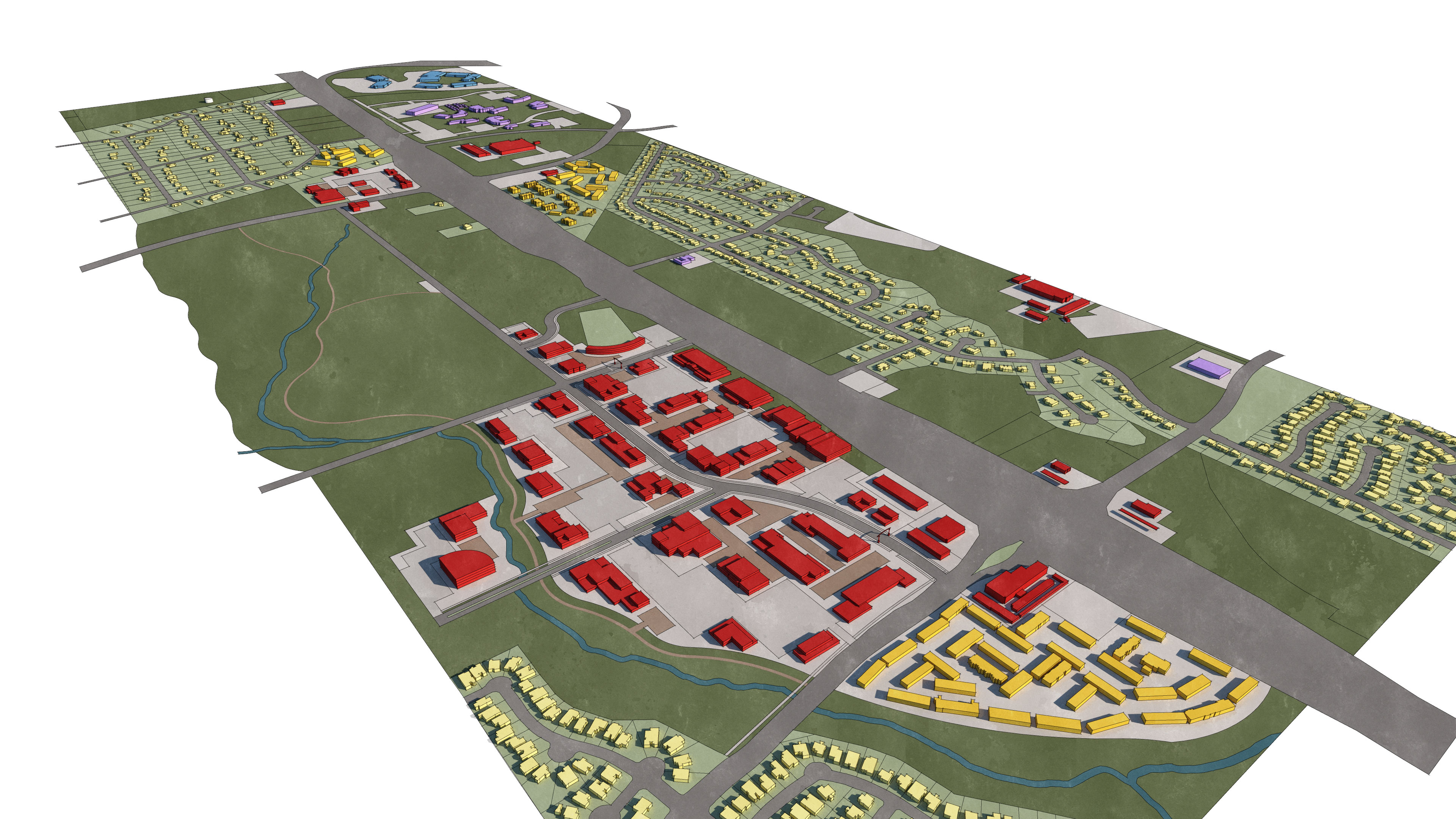
The map below highlights the Focus Areas identified for the Highway 151 and Loop 1604 Area Regional Center. To learn more about each of the five focus areas, click on the animated targeted circle.
To provide specific feedback on the map, please click and drag a box on that location of the map and fill out the comment box. We would love to hear more from you!
You can also visit the bottom of the page to leave additional feedback.
Introduction
The focus areas and corridors within the Highway 151 and Loop 1604 Area Regional Center were identified by the Planning Team and the community as areas that have capacity for growth and change and can become examples of the types of development the area would like to see in the future. While each area is unique, they all present opportunities to accommodate population and employment growth while simultaneously fulfilling the SA Tomorrow goal of creating compact walkable places where San Antonio residents can live, work, and play.
As the Highway 151 and Loop 1604 area continues to grow, there will also be growing needs for more places that attract residents, workers, students, and visitors to the area. The Planning Team members expressed a desire to see more mixed-use in targeted locations within the Plan Area, and the Focus Areas are potential sites for this type of development. The Focus Areas are envisioned as ideally mixed-use developments that incorporate parks, plazas and multimodal streetscapes.
Each Focus Area has an individually tailored vision created through conversations with the Planning Team members. The focus area visions are rooted in the context of existing land uses, proposed land uses, and the desired character and design of the areas. While some focus areas have more of a commercial focus, others are more residential and some have more retail or recreation options. Identifying the purpose, future character, appropriate building heights, and areas of transition within each focus area creates individualized areas that are unique to the Regional Center.
While these ideas for the focus areas are not necessarily going to be developed exactly as they are imagined, this exercise is intended to provide a more detailed picture for the desired types of growth within the study area as it aligns with the future land use map. While recommendations for the Regional Center plan are generally broad in terms of policy, the focus area exercise allows for more detailed conversations around building form, streetscape, and other aspects of urban design and connectivity. In the rest of this chapter, the Focus Areas are described in detail with their respective visions and potential growth opportunities, as discussed by the Planning Team and other stakeholders. In order to realize these ideas, a set of recommendations are also provided to encourage the type of growth desired for the Regional Center and its focus areas.
Recommendation #1
Encourage the creation of park, open, recreation, or civic space in the identified Focus Areas.Throughout the process for this Regional Center Plan, residents and workers all identified a lack of publicly accessible open space as a key challenge for the area. Several major landowners, such as Northwest Vista College, GM Financial, and Capital Group, have created open space within their developments on existing floodplain, to varying degrees of public access. As the area grows, publicly accessible park, open, recreation, and civic spaces will be vital for visitors, residents, and workers. These types of spaces could be created through public plazas surrounded by mixed-use development, through official park spaces, or through dedicated community centers.
Recommendation #2
Protect the established character of the Regional Center in each Focus Area by providing landscaped buffers and screening, and encouraging low impact development.Residents of the Regional Center consistently mention the “natural” or “Hill Country” character of the area when describing what they like and what they would like to preserve. Some of this character is due to the topography of the landscape and existing trees, but much of it is due to regulations in place to maintain certain requirements for development. In order to protect this established character certain regulations, such as the expansion of the Highway 151 Gateway Overlay District or the encouragement of Low Impact Development (LID) should be explored for the Focus Areas.
Recommendation #3
Support the unique vision for each Focus Area and emerging industries within the Regional Center by creating high-quality places with a mix of uses, vibrant public spaces, transit accessibility, and appropriate transitions to surrounding uses.Planning Team members had detailed discussions about the types of developments that would be desirable for the Focus Areas, and how these types of uses could support the emerging healthcare, hospitality, and financial services industries increasingly locating in the area. Of course the specifics of new developments are up to the individual developers and property owners, but zoning and land use can guide the types of developments desired. For this reason, zoning and development policies in the area should be evaluated to ensure they support and promote the community’s desired vision for the area. Transportation connectivity is also essential, and requires continued coordination with VIA Metropolitan Transit.
Focus Area #1: West Highway 151
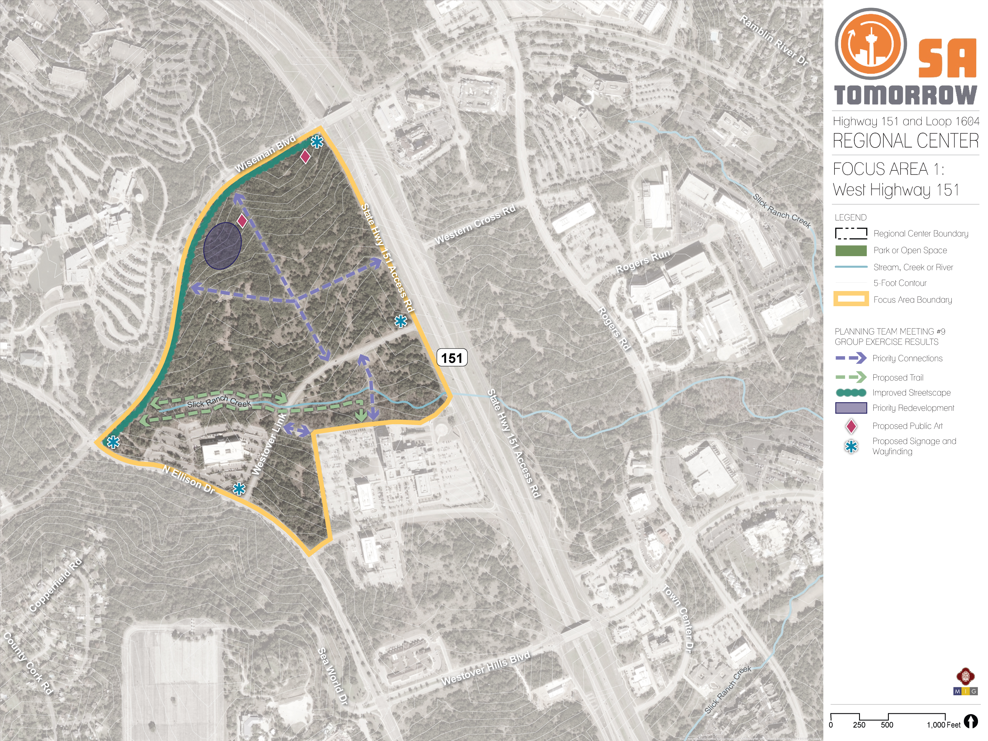
West of Highway 151 and south of Wiseman Boulevard lies a considerably large area of mostly vacant land. This site is near Northwest Vista College, the Christus Santa Rosa Hospital, and the GM Financial office. Westover Link and Slick Ranch Creek run through the focus area, providing alternative access between Highway 151 and N Ellison Drive. Although it is a natural amenity and asset for the focus area, the presence of the creek creates flooding concerns. This favorable topography alleviates major flooding issues in other parts of the focus area.
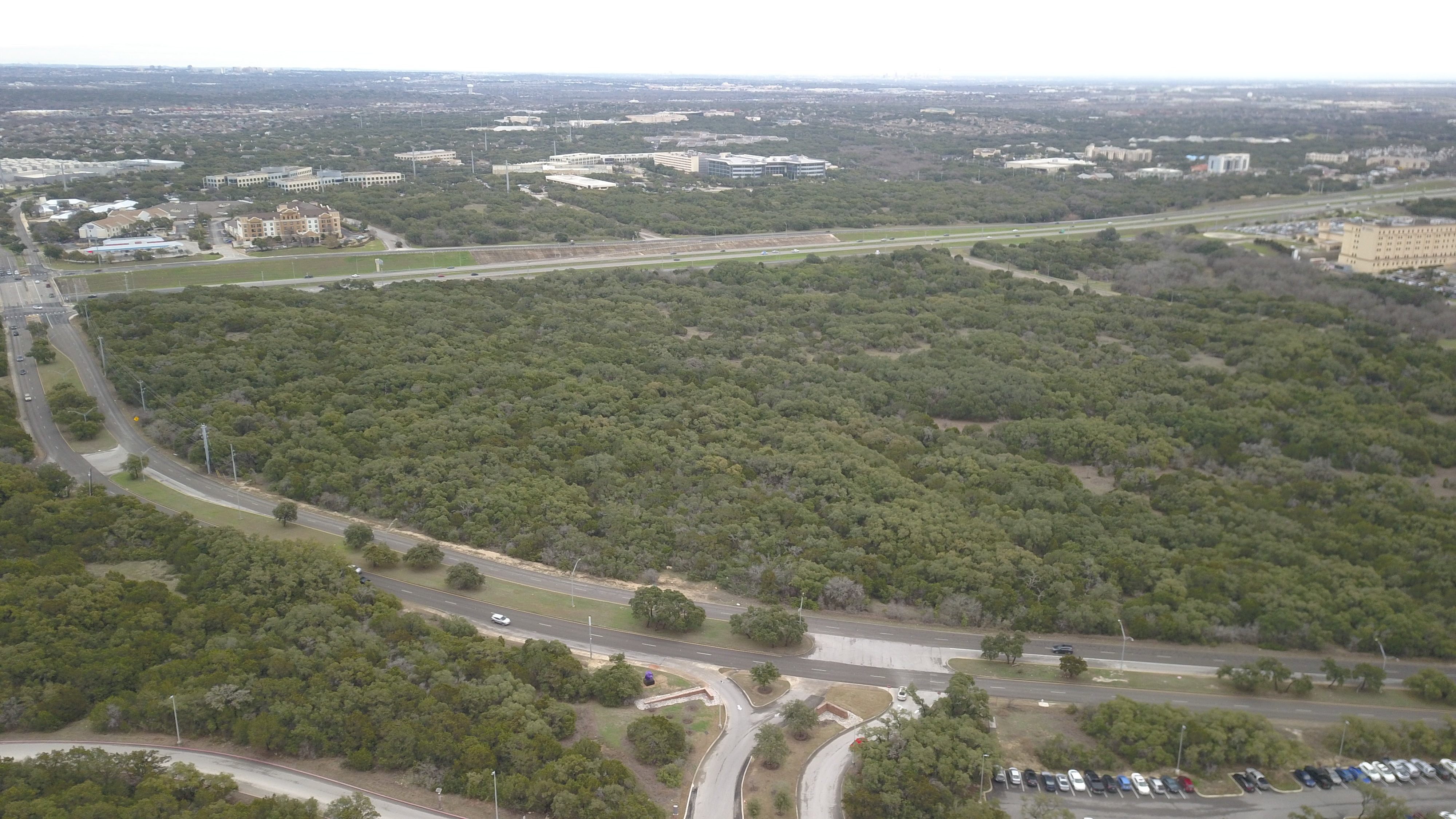
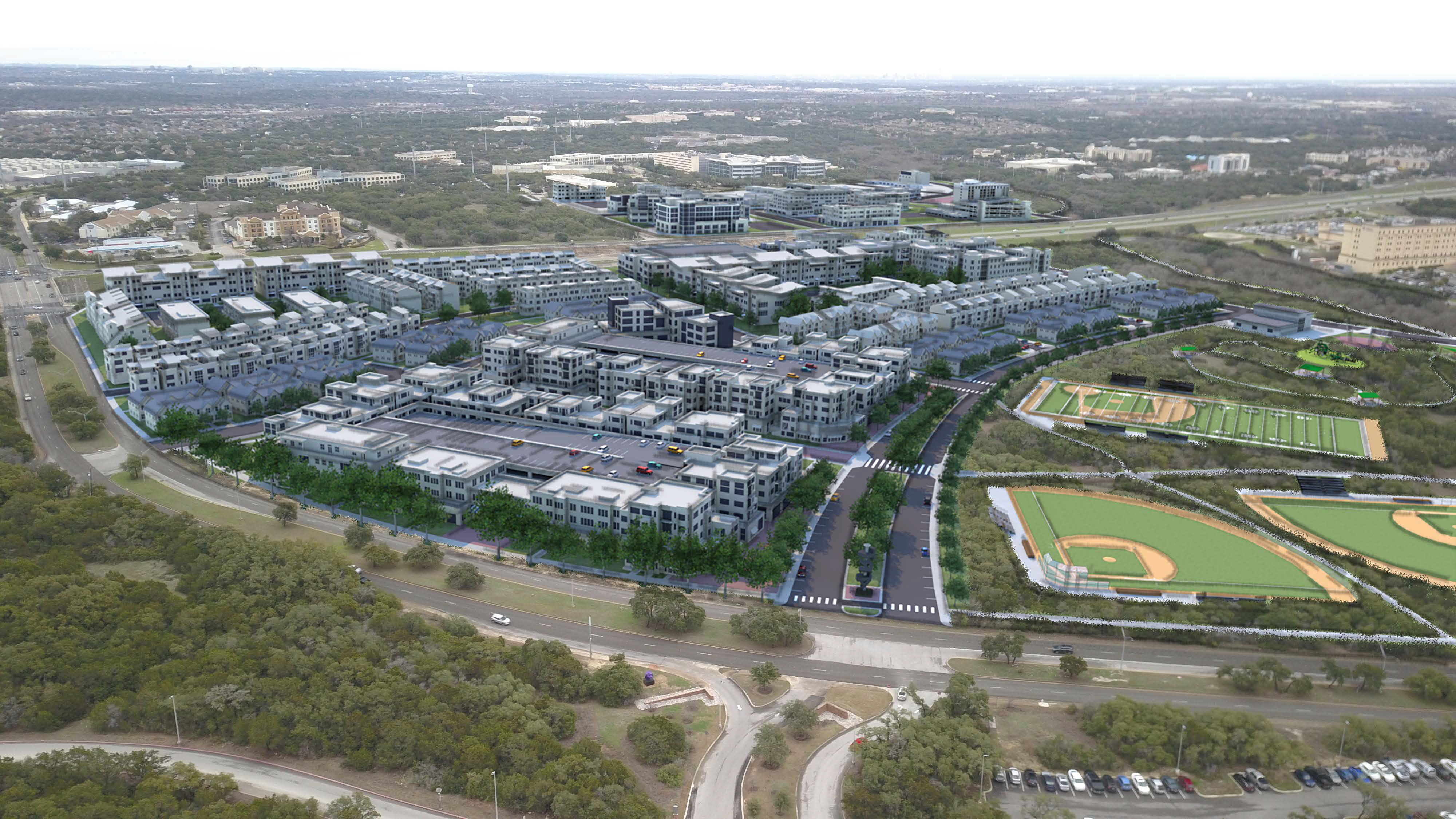
Figure 1: Digital Design Charrette Conceptual Rendering of Focus Area #1 (West Highway 151) - Looking Southeast from Wiseman Road
Vision
The vision for the West Highway 151 Focus Area is to develop the majority of the area into affordable housing options for Northwest Vista College students, recent graduates, or employees of the neighboring businesses. In addition to housing, there is a strong desire to provide a key transit connection and associated amenities to the area that could serve the focus area, Regional Center, and surrounding area. The transit connection and associated amenities will also serve retail or restaurant options for students, residents, or those waiting for transportation. Proposed public art and wayfinding along the borders of the focus area ensure safety and provide character for the proposed mixed-use vision.
To better connect the site to the surrounding area, proposed Priority Connections between the college entrance and Westover Link, as well as to Highway 151 from Wiseman Boulevard have been identified and are shown on the Focus Area map. Along Slick Ranch Creek and the floodplain area, there is strong potential for an internal trail connection, which would both alleviate drainage and impervious cover concerns and provide recreational opportunities in this Regional Center that is in short supply of green spaces. Working in combination with the proposed priority connections, the internal trail connection ensures the walkability of the mixed-use development and avoids creating superblocks. To create an enjoyable street experience, streetscape improvements along Wiseman Boulevard would provide walkability along the roadway as well as a safe direct connection between Northwest Vista College and the mixed-use development.
Transformative Project
With this serving as the largest focus area identified within the Regional Center and the largest amount of vacant land, this focus area was evaluated in more detail in a digital design charrette exercise conducted with members of the Planning Team. This exercise allowed Planning Team members to imagine what their vision for the focus area would look like with an example rendering of buildings and other concepts. A view of the conceptual design charrette design is shown in Figure 1, with the view of this rendering oriented southeast from the perspective of the Northwest Vista College. This image displays the desired mixed-use design that allows walkability within the development and to surrounding uses, such as the college campus. It also highlights the density envisioned for the development, which included a variety of housing types blended with first floor activated commercial and retail spaces. The goal was to create a walkable node where one could park and visit multiple destinations by foot.
To mitigate potential flooding issues, all structures and the majority of the impervious coverage in the area are situated outside of the floodplain. The Planning Team imagines the floodplain as a recreational asset and as an opportunity to provide potential community park and ballpark space. This provides an area that supports the future residents in the mixed-use development, the community as a whole, and encourages visitors, students, and workers to extend their stay and explore.
Focus Area #2: East Highway 151
On the other side of Highway 151 lies another considerably large area of vacant land that is located south of Wiseman Boulevard and bordered by Rogers Road to the east. Bordering the site across Rogers Road are some hotel developments and major employment centers, including One Frost, Kohl’s Operations Center, Chase, and Aetna, among others.
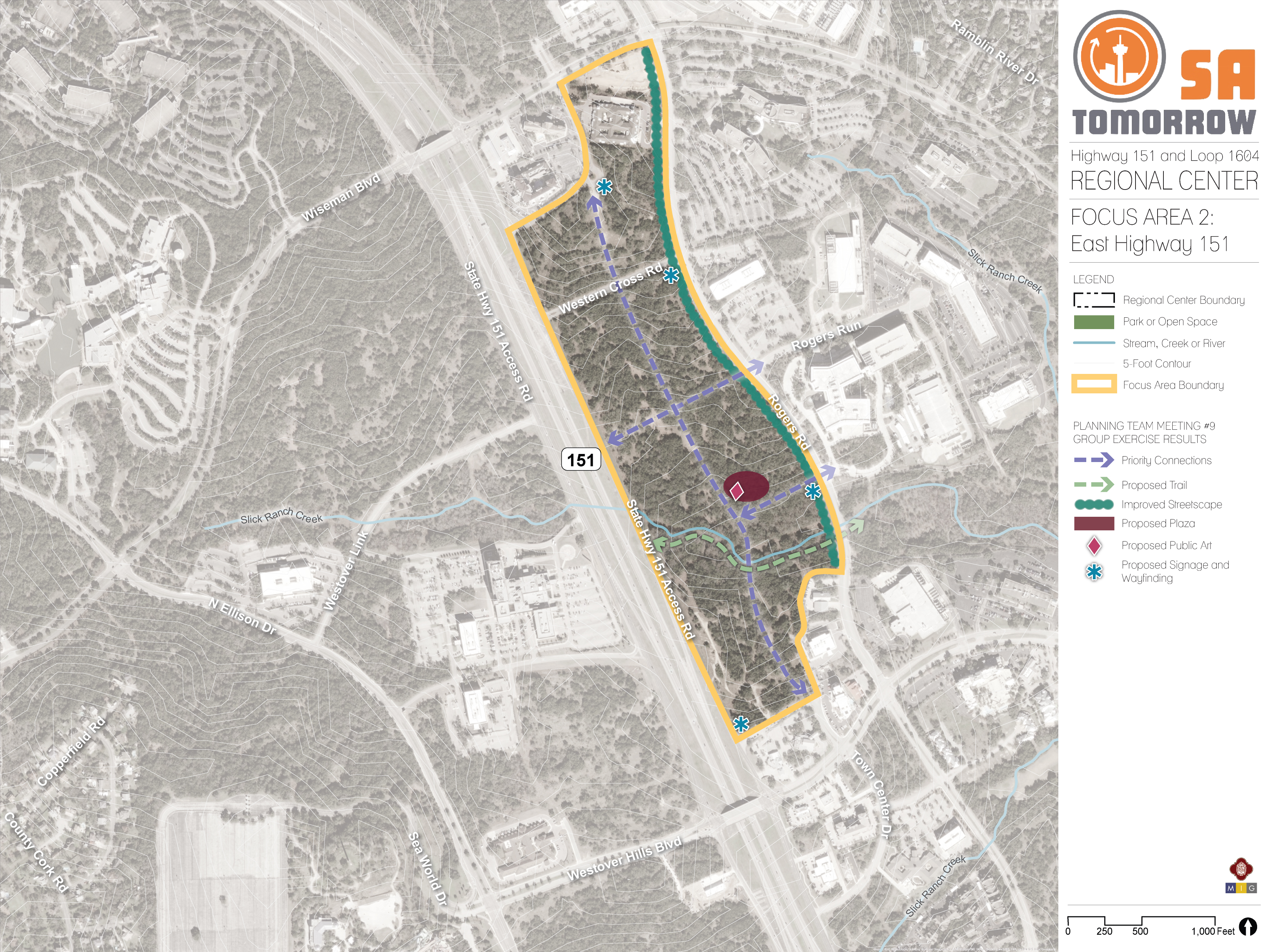

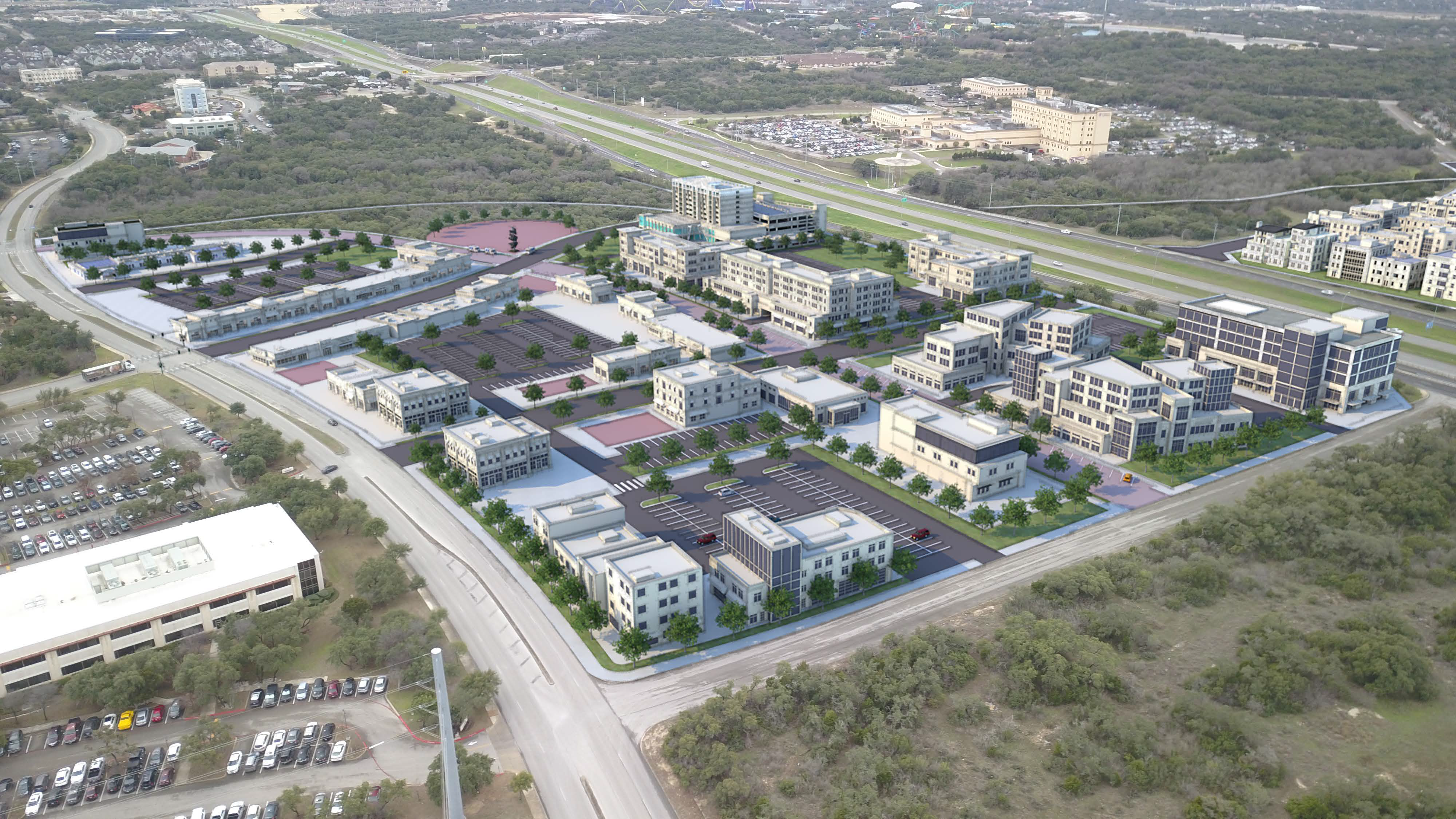
Figure 2: Digital Design Charrette Conceptual Rendering of Focus Area #2 (East Highway 151) - Looking Southwest from Wiseman Road
Vision
The vision for the East Highway 151 Focus Area is more of a hospitality hub, including restaurant options for nearby employees to frequent during their lunch breaks, due to the proximity to existing hotels and employment centers. Instead of a mixed-use area with residences and retail, this Focus Area is envisioned as more of a mix of hospitality, restaurant, and open space uses.
Similar to the West Highway 151 Focus Area, this site does not have many options for internal circulation. Creating an internal network of streets that provide a central connection from Wiseman Bouldevard to Town Center Drive and an east-west connection from Rogers Road to the Highway 151 access road supports the mixed use and pedestrian friendly environment vision of the focus area while creating a large scale grid-like pattern of development. The streetscape improvements, signage, and wayfinding proposed along Rogers Road would provide a safe and comfortable environment for residents and workers at nearby campus headquarters, such as the employees at One Frost, to walk or bike to the focus area. A proposed plaza and proposed trail extension along the creek would be community-wide destinations. Public art at the plaza and the signage and wayfinding could add character definition to the focus area.
Transformative Project
Similar to the West Highway 151 Focus Area, the vision of the East Highway 151 Focus Area was brought to life in visualizations created in response to the priorities of the Planning Team through the digital design charrette process. The proposed hospitality, retail, and dining development is shown in Figure 2 with office, open space, and restaurant uses. Although there are a variety of uses incorporated, the development appropriately reserves most of its square footage for office uses. This is compatible with the several corporate campuses located on the eastern side of Highway 151, and could accommodate smaller or larger commercial businesses as needed. Multifamily residential uses could also be incorporated to allow for more street life, and perhaps could be integrated into the hotel or office developments as appropriate.
The development is not envisioned to be insular and is designed to be accessible by foot, vehicle, or bike for residents and employees located east of Rogers Road. Plazas, promenades, and open spaces are key elements in the vision for this site, and would provide outdoor recreational and leisure opportunities to lunch-time visitors, community residents, or guests at the nearby hotels. Open space should also contain street furniture, shading, and other elements to encourage people to stay a while in all weather. Open space is located on the southern portion of the focus area. It serves as a refuge from the activity of the Regional Center and mixed use development allowing users to interact with Slick Ranch Creek.
Focus Area #3: West Loop 1604
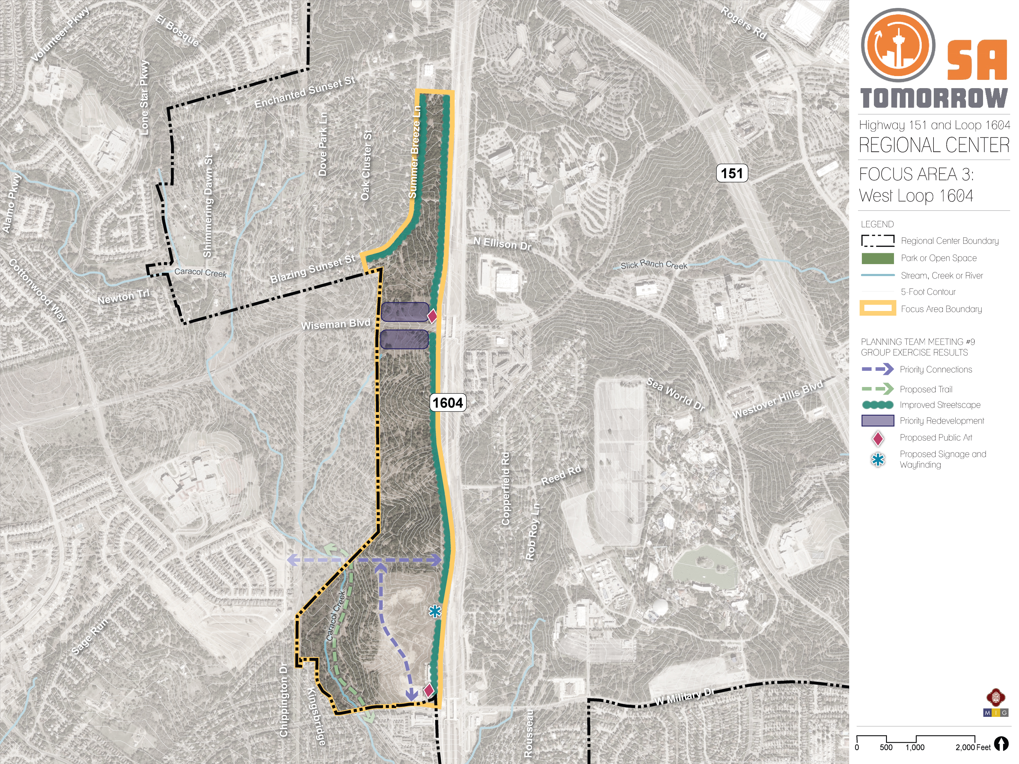
This long and narrow focus area lies west of Loop 1604, with Wiseman Boulevard running through the site and Caracol Creek creating floodplain concerns to the south. The site is predominantly vacant, although there are development plans currently underway on the southern portion of the focus area that support its overall vision. Considerable portions of the parcels in this focus area extend outside of the city limits.
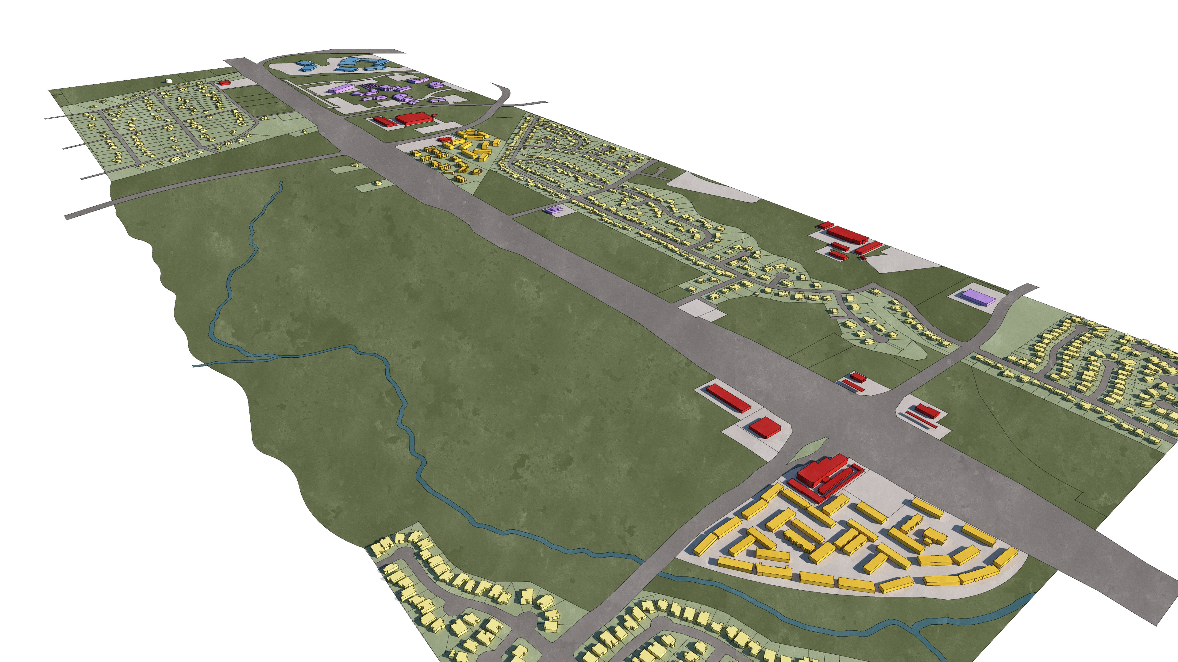
Figure 3: Focus Area 3 – Existing and Proposed Land Use/Massing
Vision
The West Loop 1604 Focus Area is envisioned as more of a commercial hub given the area’s proximity to Loop 1604. Figure 3 presents a land use and massing conceptual design for the Focus Area. Integration of priority connections and an internal trail network along Caracol Creek provide outdoor recreational opportunities and support interconnectivity goals. Signage and wayfinding and public art identifiers for this development are crucial for safe vehicular movement into and out of the development, especially along a fast-moving corridor such as the Loop 1604 frontage road.
Safety priorities are reinforced in the north portion of the focus area by integrating streetscape improvements along Summer Breeze Lane and the Loop 1604 frontage road. The streetscape improvements make pedestrian and bicyclist activity safer amongst vehicular traffic by adding more street trees, wider sidewalks, and defined crosswalks. These improvements permit residents and visitors to safely access the proposed priority redevelopment nodes adjacent to the Loop 1604 frontage road, located north and south of Wiseman Boulevard.
Focus Area #4: Wiseman Boulevard from 1604 to Rogers Road Mixed-Use Corridor
Wiseman Boulevard is one of the major connectors of the residential and commercial uses within the Highway 151 and Loop 1604 Area Regional Center. This street travels along Northwest Vista College, past Focus Area #1 and Focus Area #2, and connects into Rogers Road. The western edge of the Regional Center is the intersection of Wiseman Boulevard and Loop 1604 and is bound on the east right past the Wiseman Boulevard and Rogers Road intersection. This corridor is located at the heart of the Regional Center and is a vital component to existing and future economic development opportunities.

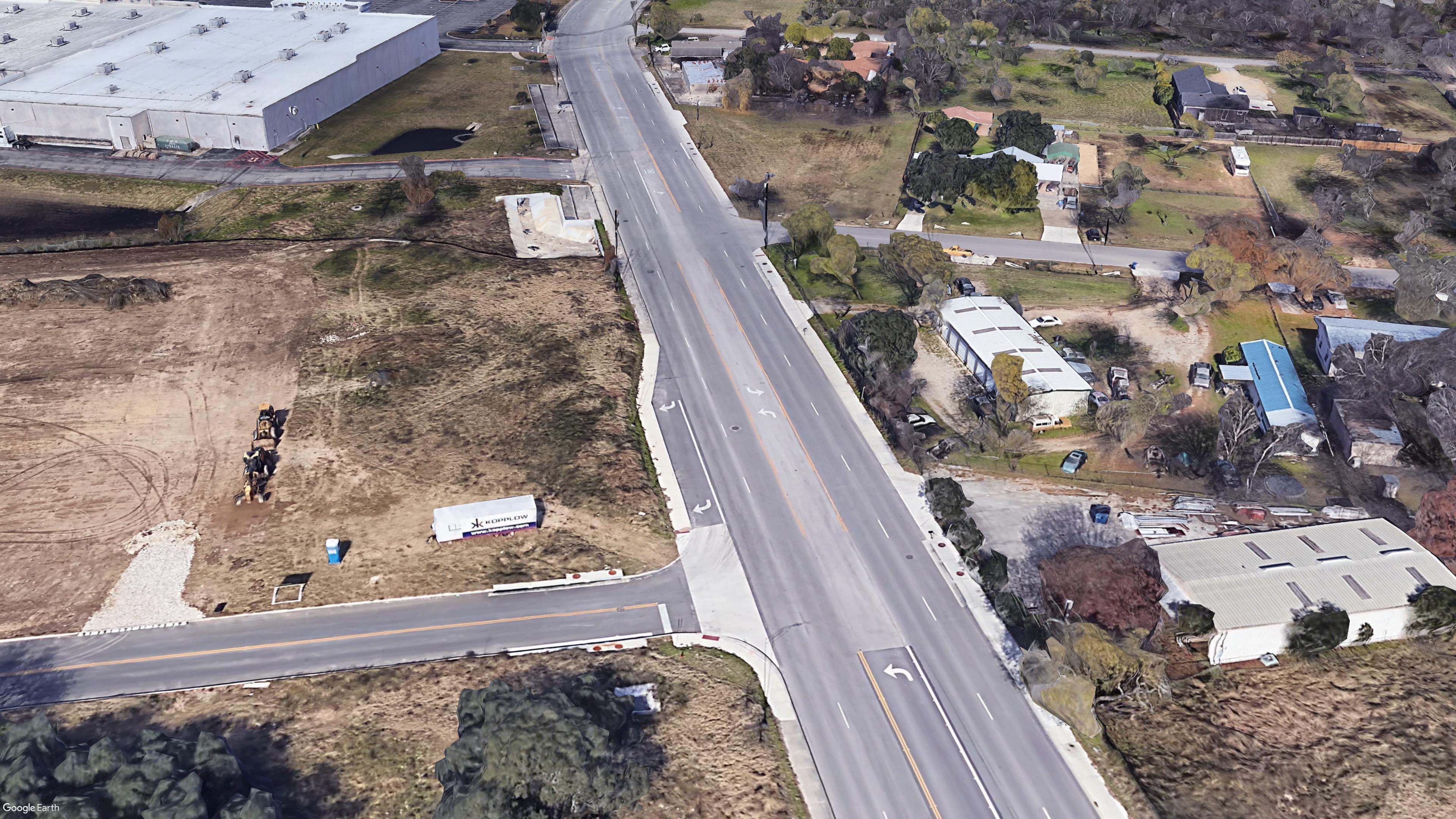
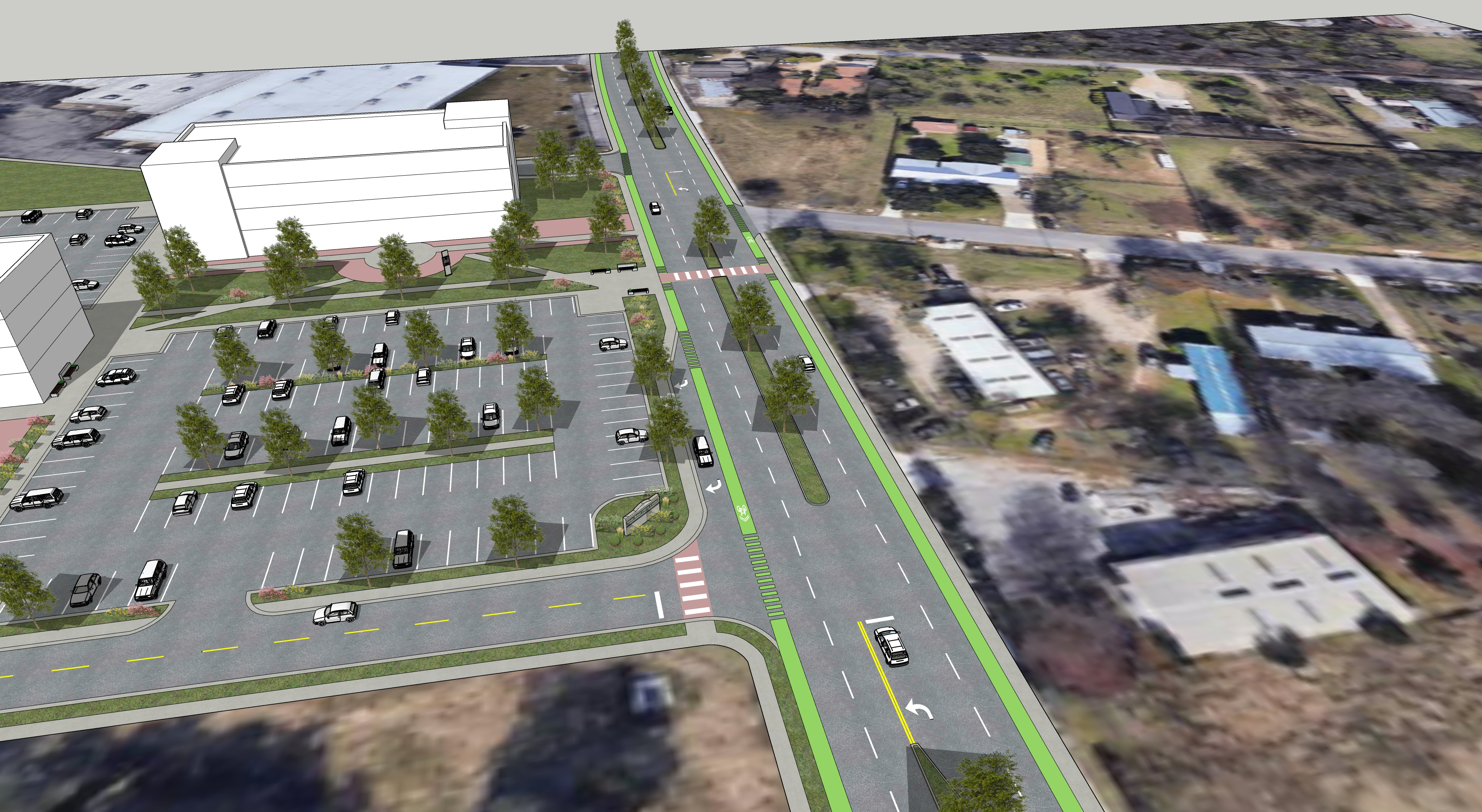
Conceptual Intersection Enhancement at Wiseman Boulevard and Northwest Vista College Entrance

Vision
Since there is considerable vacant land on either side of the Wiseman Boulevard corridor, there are major opportunities as development occurs to create a safer pedestrian, bicyclist, and transit environment along the thoroughfare. This would be especially important if there were to be transit investment within Focus Area #1. The corridor should provide safer crossings, so students form Northwest Vista College can easily walk to the mixed-use area within Focus Area #1, utilize recreational amenities, and perhaps utilize available transit options to their next destination. Improved crossings are the major need for the corridor, but also a more balanced and multimodal approach to the street traffic, which can often travel at fast speeds. An example of an improved crossing at Northwest Vista College’s entrance off Wiseman Boulevard is shown in Figure ##. These crossing improvements create an atmosphere that still accommodates all modes of transit while prioritizing the safety of pedestrians by including wide and well marked crosswalks, landscaped traffic islands, and ADA compliant sidewalks and ramps.
Focus Area #5: Rogers Road from Culebra Road to Wiseman Boulevard
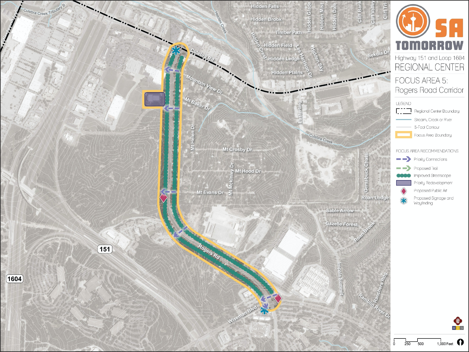
Rogers Road is another major connector for the study area. Residents of the neighborhoods on either side of the corridor describe it as a “pass through” for many motorists who are wanting to avoid traffic on either Culebra Road or Highway 151. The northern end of this focus corridor is the Rogers Road and Culebra Road intersection, with the southern end at Rogers Road and Wiseman Boulevard. This corridor has an almost rural character in areas, especially along the Mountain View Acres neighborhood. However, with a new Methodist Hospital planned for the vacant parcel behind the Culebra Market development, this corridor will need to support many other types of users in the future.
Conceptual Mixed Use or Commercial Development Along Rogers Road
Vision
This corridor is envisioned to expand to become more mixed-use and will need to support more modes of travel. Central to this will be better pedestrian crossings, in addition to safer travel for those who might be bicycling or taking transit. Figure ## shows a potential rendering for how more mixed-use activity or commercial activity could front the street, maintaining adequate parking while screening with trees and creating a desirable walking environment. Figure # also represents a vision that provides opportunity for sufficient parking necessary for large campus developments and mixed-use while providing safe access and usability for pedestrians. This concept supports the current nature of the corridor while providing opportunity for safety measures to be integrated.